Thursday, July 2, 2009

Grand Canyon - Wolrd Travelling

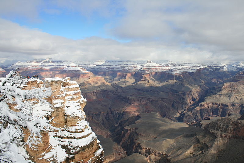
The Grand Canyon is a steep-sided gorge carved by the Colorado River in the United States in the state of Arizona. It is largely contained within the Grand Canyon National Park — one of the first national parks in the United States. President Theodore Roosevelt was a major proponent of preservation of the Grand Canyon area, and visited it on numerous occasions to hunt and enjoy the scenery. View from Grandview Point. A map of the Grand Canyon and surrounding areas, circa 1908.
Longstanding scientific consensus has been that the canyon was created by the Colorado River over a six million year period. The canyon is 277 miles (446 km) long, ranges in width from 4 to 18 miles (6.4 to 29 km) and attains a depth of over a mile (1.83 km) (6000 feet). Nearly two billion years of the Earth's geological history have been exposed as the Colorado River and its tributaries cut their channels through layer after layer of rock while the Colorado Plateau was uplifted. The "canyon began in the west, followed by another that formed in the east. Eventually, the two broke through and met as a single majestic rent in the earth some six million years ago. The merger apparently occurred where the river today bends to the west, in the area known as the Kaibab Arch."
Before European immigration, the area was inhabited by Native Americans who built settlements within the canyon and its many caves. The Pueblo people considered the Grand Canyon ("Ongtupqa" in Hopi language) a holy site and made pilgrimages to it. The first European known to have viewed the Grand Canyon was García López de Cárdenas from Spain, who arrived in 1540.

Get in
Grand Canyon area map

By car

The majority of visitors to the South Rim of the park arrive from the south on Arizona Route 64 (AZ 64) (conjoined with US highway 180). Alternately, one can enter the south rim from the east on AZ64.

For the south entrance: from Flagstaff, you can take US Route 180 (US 180) northwest to Valle where it joins with AZ 64, and continue north to the south rim; or take I-40 west toward Williams to the junction with AZ 64 and continue north to the south rim. Both routes are approximately 80 miles (129 km). The approx 60 miles (97 km) on US 180 is a narrow 2-lane mountain road through a heavily forested area. The I-40 west is a wide multi-lane interstate for approx 20 miles (32 km), to AZ 64 which is a slightly wider, less mountainous 2-lane highway, and the recommended route during winter weather. There are two lanes at this entrance reserved for pass and prepaid entrance fees (now lanes 1 and 4), which can be pre-purchased outside of the park at the National Geographic Theater/Visitor Center.

For the east entrance, take US 89 south from Page, AZ or north from Flagstaff to the junction with AZ 64 at Cameron. It is approx 25 miles (40 km) from the junction to the east entrance of the park, and approx 25 miles (40 km) from the east entrance to the south rim village area.

Visitors to the North Rim use ALT US 89 to AZ 67 (closed in winter).

By plane
Many Grand Canyon visitors fly into one of two metropolitan airports located within half a day's drive of the South Rim: Las Vegas McCarran International Airport (LAS), which is 275 miles from the South Rim or Phoenix Sky Harbor Airport (PHX), 230 miles from the South Rim.

Flagstaff's Pulliam Field (FLG) is the nearest commercial airport to the canyon. Two daily flights from Los Angeles (LAX) are offered by Horizon Air, and US Airways operates five daily flights from Phoenix. Commuter flights are also available from Phoenix to Page-Lake Powell, Arizona (PGA) on Great Lakes Air, 145 miles Northeast of the park .

Grand Canyon National Park Airport (GCN) is located just outside of the South Rim entrance in the town of Tusayan. It is primarily utilized by companies who provide Grand Canyon air tours and private aircraft. Scheduled air service from Las Vegas to the Grand Canyon is offered by Scenic Airlines, departing out of the Boulder City Municipal Airport (61B). Private charter service is available from other cities. Generally, though, visitors fly commercial airlines into the larger airports in Flagstaff, Phoenix, or Las Vegas.

By bus
Open Road Tours, 877-226-8060. runs a daily shuttle service to the South Rim from Flagstaff.

There are currently no bus lines offering transportation to either rim. However, several commercial tour companies offer guided tours originating in Flagstaff, Phoenix, Las Vegas, Los Angeles and other locations, either directly to the South Rim or that include the South Rim as part of an itinerary, and a few offer tours which include a visit to the North Rim.

By guided tour
A number of companies provide guided tours of the Canyon that include transportation from the surrounding areas. Some companies will provide bus travel from nearby towns while others begin in the park. Some will provide just a brief tour with small stops, while others may take you on a hike, and arrange all your meals.

By train
The Grand Canyon Railway operates a train ride from the town of Williams to the Grand Canyon Village (travel time is 2.5 hours in each direction). The terminus at Grand Canyon Village is within walking distance of some accommodations. The train features an historic steam locomotive during the summer season, restored Pullman cars, and a staged old west style shootout. However, the Grand Canyon is not visible from the train. It is simply another option for traveling to the canyon, and takes about twice as long as driving to the canyon.

Amtrak's Southwest Chief, with trains operating daily between Chicago and Los Angeles, stops at Williams Junction, with connections to the Grand Canyon Railway.

Fees/Permits
All private vehicles entering the Grand Canyon must pay a $25 entrance fee, which is good for seven days. Individuals on foot or on a bike must pay a $12 entrance fee, also good for seven days. Exceptions: those holding an Annual Pass ($80, good for one year), Senior Pass ($10, good for life, available to US citizens 62 and older) or an Access Pass (free, available only to citizens or permanent residents of the United States who are medically determined to be blind or permanently disabled). Note: An Access Pass can only be obtained in person by showing proof of medically determined permanent disability, or eligibility for receiving benefits under federal law.

Get around

Some of the view points are reachable by car, park service shuttle, motorcoach tour or on foot.

You can go into the canyon by horse, by mule (through guided tours on the south rim from Xanterra, on foot or by boat.

Private stock users (equines only) are required to follow a number of rules and restrictions while in the park, and must get a permit from the park service for overnight use. See Private Stock Use on the park service website for specifics.

From March through November the West Rim Drive is not accessible to most private vehicles (handicap vehicles may request a variance at the entry gate). The park service runs a shuttle during this time. The shuttles are frequent, but long lines form during the busy summer months.

Trans Canyon Shuttle an independent shuttle service runs between the North and the South Rim (No website, Tel 1.928.638.2820).

Friday, June 26, 2009

Eiffel Tower - Paris - Franch


The Eiffel Tower is an Iron Tower built on the Champ de Mars beside the Seine River in Paris. The tower has become a global icon of France and is one of the most recognizable structures in the world.

Sourch : Wikipedia

Monas Tower - Jakarta


The Monumen Nasional (or Tugu Monas, the National Monument tower) is a 450 ft (137 m) tall tower in Central Jakarta , symbolizing the fight for Indonesia's independence. Construction began in 1961 under Sukarno and was not finished until 1975 under Suharto. It is topped by a 14.5 ton bronze flame, which is plated in 35 kg (1,125 troy ounces) of gold.

The entrance to the monument is located at the north part of Medan Merdeka Park, near the Prince Diponegoro statue. From the entrance and underground ticket box, the visitor get through a tunnel under stone-pavement arround the monument to the central part of the park. On inner part of walls surround the monument in central part of the park, there is a series of statues and reliefs depicted the history on Indonesia that span from ancient empire of Majapahit to the history of modern Indonesia. Visitors can take an elevator up to upper platform beneath the golden flame with a view of Medan Merdeka Park, Istiqlal Mosque, and the city. At the middle part is the Cawan (Indonesian: cup) with viewing middle platform on top of it. The Cawan is a reverted pyramid structure that engulfed the base of towering obelisk shaft. Inside the Cawan there is Ruang Tenang (solemn hall) or Ruang Agung (grand hall) with black marble square walls at the center of it. The four sides of central black marble wall displaying a carved golden gate that houses the text of Indonesian Proclamation of Independence in 1945, Garuda Pancasila (Coat of Arms of Indonesia), the map of Indonesian archipelago, The flag of Indonesia, and the flags of Indonesian provinces. The golden gate is opened several times in a day displaying the text of Indonesian declaration of independence and playing the record of Soekarno's voice reading the declaration. In the lower part inside the base of the monument is an exhibition hall with several dioramas showing the history of Indonesia.

Sourch : Wikipedia

Petronas Tower - Malaysia

Petronas Tower

The Petronas Twin Towers (also known as the Petronas Towers or just Twin Towers), in Kuala Lumpur, Malaysia are twin towers and were the world's tallest buildings, before being surpassed by Taipei. However, the towers are still the tallest twin building in the world. They were the world's tallest buildings from 1998 to 2004 if measured from the level of the main entrance to the structural top, the original height reference used by the US-based Council on Tall Buildings and Urband Habitat from 1969 (three additional height categories were introduced as the tower neared completion in 1996).


Sourch : Wikipedia

Monday, April 13, 2009

Egyptian pyramids


The Egyptian pyramids are ancient pyramid-shaped masonry structures located in Egypt.

There are over 100 pyramids in Egypt. Most were built as tombs for the country's Pharaohs and their consorts during the Old and Middle Kingdom periods.

The earliest known Egyptian pyramid is the Pyramid of Djoser which was built during the third dynasty. This pyramid and its surrounding complex were designed by the architect Imhotep, and are generally considered to be the world's oldest monumental structures constructed of dressed masonry.

The best known Egyptian pyramids are those found at Giza, on the outskirts of Cairo. Several of the Giza pyramids are counted among the largest structures ever built.

The Pyramid of Khufu at Giza is the largest Egyptian pyramid. It is the only one of the Seven Wonders of the Ancient World still in existence.


The History

By the time of the early dynastic period of Egyptian history, those with sufficient means were buried in bench-like structures known as mastabas.

The first historically documented Egyptian pyramid is attributed to the architect Imhotep, who planned what Egyptologists believe to be a tomb for the pharaoh Djoser. Amenhotep is credited with being the first to conceive the notion of stacking mastabas on top of each other — creating an edifice composed of a number of "steps" that decreased in size towards its apex. The result was the Step Pyramid of Djoser — which was designed to serve as a gigantic stairway by which the soul of the deceased pharaoh could ascend to the heavens. Such was the importance of Imhotep's achievement that he was deified by later Egyptians.

The most prolific pyramid-building phase coincided with the greatest degree of absolutist pharaonic rule. It was during this time that the most famous pyramids, those near Giza, were built. Over time, as authority became less centralized, the ability and willingness to harness the resources required for construction on a massive scale decreased, and later pyramids were smaller, less well-built and often hastily constructed.

Long after the end of Egypt's own pyramid-building period, a burst of pyramid-building occurred in what is present-day Sudan, after much of Egypt came under the rule of the Kings of Napata. While Napatan rule was brief and ceased in 661 BC, the Egyptian influence made an indelible impression, and during the later Sudanese Kingdom of Meroe (approximately in the period between 300 BC–300 AD) this flowered into a full-blown pyramid-building revival, which saw more than two hundred indigenous, but Egyptian-inspired royal pyramid-tombs constructed in the vicinity of the kingdom's capital city.


Pyramid symbolism

The shape of Egyptian pyramids is thought to represent the primordial mound from which the Egyptians believed the earth was created. The shape is also thought to be representative of the descending rays of the sun, and most pyramids were faced with polished, highly reflective white limestone, in order to give them a brilliant appearance when viewed from a distance. Pyramids were often also named in ways that referred to solar luminescence. For example, the formal name of the Bent Pyramid at Dahshur The Southern Shining Pyramid, and that of Senwosret at el-Lahun was Senwosret is Shining.

While it is generally agreed that pyramids were burial monuments, there is continued disagreement on the particular theological principles that might have given rise to them. One theory is that they were designed as a type of "resurrection machine."

The Egyptians believed the dark area of the night sky around which the stars appear to revolve was the physical gateway into the heavens. One of the narrow shafts that extends from the main burial chamber through the entire body of the Great Pyramid points directly towards the center of this part of the sky. This suggests the pyramid may have been designed to serve as a means to magically launch the deceased pharaoh's soul directly into the abode of the gods.

All Egyptian pyramids were built on the west bank of the Nile, which as the site of the setting sun was associated with the realm of the dead in Egyptian mythology.

Number and location of pyramids

In 1842 Karl Richard Lepsius produced the first modern list of pyramids, in which he counted 67. A great many more have since been discovered. As of November 2008, 118 Egyptian pyramids have been identified.

The location of Pyramid 29, which Lepsius called the "Headless Pyramid", was lost for a second time when the structure was buried by desert sands subsequent to Lepsius' survey. It was only rediscovered again during an archaeological dig conducted in 2008.

Many pyramids are in a poor state of preservation or buried by desert sands. If visible at all they may appear as little more than mounds of rubble. As a consequence archaeologists are continuing to identify and study previously unknown pyramid structures.

The most recent pyramid to be discovered is that of Queen Sesheshet, mother of 6th Dynasty Pharaoh Teti, located at Saqqara. The discovery was announced by Zahi Hawass, Secretary General of the Egyptian Supreme Council of Antiquities, on 11 November 2008.

All of Egypt's pyramids are sited on the west bank of the Nile, and most are grouped together in a number of pyramid fields. The most important of these are listed geographically, from north to south, below.

Source : WIKIPEDIA

Friday, March 20, 2009

Golden Temple Park - Jindian Park- Yunan - Chinese

Golden Temple Park, or Jindian Park (traditional Chinese: Jīndiàn Gōngyuán), is the largest Taoist Tongwa (bronze-tiled) temple in China and has been preserved almost completely since it was first built.

It is located on the Mingfeng Mountains, seven kilometres to the east of Kunming city, there is a fine building made of bronze. It is commonly known as Jindian (the "Golden Temple").

The Golden Temple was first built in the 30th year of Emperor Wanli's rule (1602) in the Ming Dynasty. Yunnan was ordered to send the bronze ore from Dongchuan to central China to make coins. But a war blocked the road. The governor of Yunnan, Chen Yongbing, and Qianguogong, the Duke of Guizhou Province, Mu Changzuo, ordered that the bronze be used to build a temple in imitation of the Taihe Palace and the Golden Temple on Tianzhu Peak in the Wudang Mountains, Hubei Province. The temple was later moved to the Jizu Mountains in western Yunnan. During the reign of the Qing Emperor Kangxi (1662-1722), Wu Sangui, a military general, rebuilt the temple, keeping the original Hubei design. The bronze used weighed over 200 tons.The temple walls were made with cast panels covered with exquisite and diverse designs. They are examples of the smelting and casting techniques in Yunnan a few centuries ago.

In front of the staircase outside the Golden Temple, the wide branched camellias are called "Diechi" (Butterfly Wings). They are covered with thousands of flowers in the depth of winter. The two myrtles close by were planted in the Ming Dynasty.

At the top of the mountain behind the temple hangs a 14-ton "Great Bell of the Ming Yongle Era". 2.1 meters tall and 6.7 meters in circumference, the bell was cast in the 21st year of the Yongle era (1424), over 560 years ago. It used to hang in Xuanhua Mansion in Kunming to announce the time. When Kunming expanded however, it was moved to the Golden Temple. In recent years, the Temple has been expanded several times when the "Parrot Garden", the "Camellia Garden", and the "Orchid Garden" were added.

Source : Wikipedia

Kinkaku-ji Golden Temple - Kyoto - Japan

Kinkaku-ji or "Golden Pavilion Temple" is the informal name of Rokuon-ji or "Deer Garden Temple" in Kyoto, Japan. It was originally built in 1397 to serve as a retirement villa for Shogun Ashikaga Yoshimitsu, as part of his estate then known as Kitayama.[1] It was his son who converted the building into a Zen temple of the Rinzai school. The temple was burned down twice during the Ōnin War.

The Golden Pavilion, or Kinkaku, is a three-story building on the grounds of the temple. The top two stories of the pavilion are covered with pure gold leaf. The pavilion functions as a shariden, housing relics of the Buddha (Buddha's Ashes). The top floor is built in traditional Chinese style, and the middle floor in sober Zen-style. The ground floor is rendered in shinden-zukuri-style, without gold leaf. The building is often linked or contrasted with Ginkaku-ji, the Silver Pavilion Temple, which is also located in Kyoto.


The Golden Pavilion is set in a magnificent Japanese strolling garden (kaiyū-shiki). The pond in front of it is called Kyōko-chi (Mirror Pond). There are many islands and stones on the pond that represent the Buddhist creation story.

In 1950, the pavilion was burned down by a monk, who then attempted suicide on the Daimon-ji hill behind the building. He survived, but during the investigation after the monk's arrest, his mother was called in to talk with the police; on her way home, she committed suicide by jumping from her train into a river valley. The monk was sentenced to seven years in prison; he died of illness during his imprisonment in 1956. At that time, the statue of Ashikaga Yoshimitsu was burned. A fictionalized version of these events is at the center of Yukio Mishima's 1956 book The Temple of the Golden Pavilion.


The present structure dates from 1955. Recently, the coating of Japanese lacquer was found a little decayed, and a new coating as well as gilding with gold-leaf, much thicker than the original coatings, was completed in 1987. Additionally, the interior of the building, including the paintings, was also restored. Finally, the roof was restored in 2003.

Source : Wikipedia

Carnival in Rio de Janeiro

Rio Carnival

Once a pagan celebration in ancient Rome, Carnival in Rio de Janeiro is now considered one of the greatest shows on Earth. Rio de Janeiro is known as the cultural capital of Brazil and was the administrative capital from 1822 to 1960, when Federal Government moved to the new capital, Brasilia. The first festivals of Rio date back to 1723.


Parade

The famous carnival parade has been going on since the 1930s. The parade starts Sunday evening and continues into early morning Monday of the celebration. Until 1984, when it was moved to Av. Presidente Vargas, the parade took place at Praca Onze. In 1984 the parade finally found its permanent home, the Sambadrome ["sambódromo" in Portuguese]. The Sambadrome is a large structure that was built in the downtown area, which includes several buildings that make a circular open area in the middle. In the off season, the buildings of the Sambadrome are used as classrooms for the local public schools.

Street Carnival

As the parade is taking place in the Sambadrome and the balls are being held in the Copacabana Palace and beach, many of the carnival participants are at other locations. Street festivals are very common during carnival and are highly populated by the locals. Elegance and extravagance are usually left behind, but music and dancing are still extremely common. Anyone is allowed to participate in the street festivals. Bandas and bondos are very familiar with the street carnival especially because it takes nothing to join in on the fun expect to jump in. One of the most well known bandas of Rio is Banda de Ipanema. Banda de Ipanema was first created in 1965 and is known as Rio’s most irreverent street band.

Source : Wikipedia

Great Wall of China


The Great Wall of China"The long wall of 10,000" is a series of stone and earthen fortifications in China, built, rebuilt, and maintained between the 5th century BC and the 16th century to protect the northern borders of the Chinese Empire from Xiongnu attacks during the rule of successive dynasties. Several walls, referred to as the Great Wall of China, were built since the 5th century BC. One of the most famous is the wall built between 220–206 BC by the first Emperor of China, Qin Shi Huang; little of it remains; it was much farther north than the current wall, which was built during the Ming Dynasty.


The Great Wall stretches over approximately 6,400 km (4,000 miles) from Shanhaiguan in the east to Lop Nur in the west, along an arc that roughly delineates the southern edge of Inner Mongolia, but stretches to over 6,700 km (4,160 miles) in total. At its peak, the Ming Wall was guarded by more than one million men. It has been estimated that somewhere in the range of 2 to 3 million Chinese died as part of the centuries-long project of building the wall.

Source : Wikipedia

Thursday, March 19, 2009

Opera House Sydney - Australia

Lest go to Sydney Australia, its some interesting places in the world. Its called Opera House Of Sydney.
An Australian icon of modern architecture, Sydney's Opera House commands a formidable reputation as a modern wonder of the world. The building, designed by Danish architect Jørn Utzon, was officially opened on 20 October 1973 and has inspired awe in visitors ever since.


The Sydney Opera House is a 5 to 7 minute walk from Circular Quay. Buses, trains and ferries provide easy access to Circular Quay.

There is a free shuttle bus service, designed for elderly and less mobile customers. Seating is limited and available only on a first come, first served basis. The bus departs Circular Quay at stand E in front of Wharf 2. Pick-ups for return trips are near the vehicle turning area at the Opera House, close to all the venues.

Source : http://www.travellerspoint.com/